


Patagonia- Hiking the W
- thebrieadventure

- Nov 20, 2017
- 7 min read

Patagonia
The legendary beauty of Patagonia paired with the stunning photos of Torres Del Paine on National Geographic’s website, firmly placed hiking Patagonia on my bucket list. However, after going on long, occasionally rainy, and slightly miserable hikes for work, I had a hard time justifying using my precious leave days to hike more when I could go to some exotic beach instead. Except for the fact that the Patagonian scenery is about a million times more beautiful than the hills of Quantico and that I was allowed to bring wine to enjoy along the way. After doing a lot of research on what the best time of year is for hiking, where the best routes are, how to get there, etc. I built a plan on powerpoint and emailed it out to my adventurous friends to see who was interested in traipsing around Chile with me for a week.

Several weeks later a group of five of us were finalizing dates for rendezvousing in Puerto Natales and deciding who would bring what on the group packing list. The daily itinerary ensured that we maximized our time to see as much as possible and that we hiked slick without our big bags whenever possible. There are two main routes around Torres Del Paine highlighted on the map and we decided on the red trail, the famous “W,” which was five days and four nights. It takes 9 days on average to complete the full green trail circle, but since we were all on tight schedules we opted for the slightly shorter hike.
Day 1- We caught the early morning bus from Puerto Natales (8.000 CLP), checked into the park at Pudeto (paying our park entrance fees- 21.000 CLP), and then caught the catamaran to Paine Grande (18.000 CLP). One of my brilliant planning measures (which was highlighted in the daily itinerary and reiterated on the group packing list) was to ensure that we all purchased alcohol in Puerto Natales the night before departing so that we could sip on tasty beverages at the end of every day while enjoying the magnificent panoramas. To avoid lugging around glass bottles, I brought collapsible 64oz. water bags to fill. While I stand by the genius of this plan, unfortunately my bag had a leak which was only discovered at the end of the ferry ride as we prepared to debark the catamaran. As I collected my bag from the mound of packs, I realized that it was relatively soaked, not from the spray of water, but with my Savignon Blanc (thankfully I had opted for white wine!). More than one passerby commented about the smell of booze as I passed, which I sheepishly ignored. Thankfully the rain and sweat quickly washed it away as we began hiking.
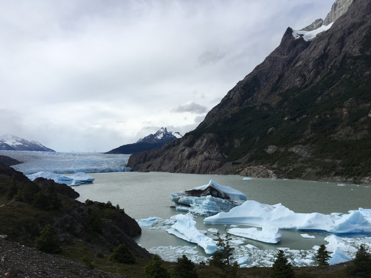
After arriving in Paine Grande, we strapped our packs on and headed up towards Refugio Grey, our first night’s campsite. The path winded uphill gradually, along the Lago Grey providing the first lookouts of glaciers along the way. The trek took about 3 hours and we arrived mid-afternoon. After setting up tents (6.000 CLP) we headed down to the nearby beach to check out the icebergs and found an excellent vantage point for the glacier field where we watched large chunks of the ice crack and thunderously fall into the icy waters below. We crawled all over the rocks and got low enough to where I very cautiously leaned out, balancing between floating ice and land to carefully lick one of the larger icebergs in the bay. We headed back to the camp site and were pleased to find that the surprisingly good facilities offered hot water for showering (from 1900-2230 daily) and dining areas with sinks and enough counter space for everyone to set up jetboils.

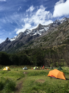

Day 2- Leaving our tents and taking only daypacks, we hiked up to the north towards Paso crossing over the suspension bridge and getting more views of the massive southern icefield. We returned to Refugio Grey around lunchtime and packed up to make the return trek back down to Paine Grande where we spent the night (7.000 CLP). This day was the easiest because it had the least distance and a good portion of it was downhill, but it enabled us to set up early and claim a good camping spot close to the mountains. Since Paine Grande sits in an open valley, the winds are extremely powerful pushing through the area making the space beside the mountains prime real estate for campers. Our tents definitely required all of the ropes and stakes we brought to keep them upright through the night. After strapping the tents down, we escaped from the cold winds into the dining hall to share several cups of green tea and Jameson, until we were sufficiently warmed up to brave the howling winds!

Day 3- After a cold windy night, we packed everything up and hit the trail early. This was the longest day of hiking and the weather changed frequently from blue skies and mild temperatures to heavy rain, but the trails were not crowded and we easily made good time. The day started like the opening scenes of Lord of the Rings leaving the beautiful open fields of the Shire and heading towards the steeper and rockier terrain. After two hours we made it to Campamento Italiano, dropped our packs, and headed up to Mirador Frances where we were rewarded with some of the most stunning views of the trip.
The clouds scattered and sunshine streamed down highlighting the luscious green forest we had been hiking through and making the snow glitter on the distant mountain peaks. Eventually we forced ourselves down from the lookout, collected our bags from Italiano and continued on to the Los Cuernos (8.500 CLP).
The camp site there provided raised wooden platforms large enough for most two man tents with a mini porch that was enough extra space for airing out clothes and boots. The best part was the adjacent massive wooden lodge which served full hot meals. Although the Mountain House Meals that were the basis of our diet for the week seemed like gourmet meals after being accustomed to MREs, they did not hold a candle to the feast that was provided. The steaming platters of hearty chicken legs, roasted veggies, and doughy bread rolls were heavenly after the long day of hiking. After slightly gorging ourselves, we ended with a night cap of Chilean Cabernet in our tin mugs while gazing up at the streams of waterfalls cascading down the mountains.


Day 4- After a full breakfast at the lodge, a little fatter and happier we continued on our way around the bottom right side of the W towards Campamento Chileno. This portion of the trail is certainly the steepest and for us it was also the wettest. The trail goes along the Lago Nordernskjöld, where we hung out on the rocky beach to enjoy a picnic lunch. When our last campsite was finally in side across the river and about a mile away, the downpour truly started. By the time we made it to the shelter and crammed ourselves inside, there was a full crowd of sopping wet people struggling for a seat close to the fireplace. Although we had planned to do the 45 min hike up to visit the Torres that evening, we easily came to a group consensus to postpone the hike up until the next morning when hopefully the weather would be a little more in our favor. After falling uphill through the mud to our wooden platforms and setting up our tents in the rain, we spent the rest of the evening playing cards and drinking wine in the warm dry shelter.

Day 5- We woke to the persistent sound of rain pattering on the tents. Laying in our sleeping bags we talked back and forth between the tents until finally deciding it was time to get up and slide down the muddy slope back to the shelter. We proceeded to have a lengthy discussion over breakfast about whether it was worthwhile to do the hike in the rain since visibility would be limited at the top. Eventually we all decided to go for it, grabbed essentials, and sped there as quickly as possible. The uphill portion in the final stretch seemed never ending, but the rain kept us cool as we determinedly climbed up the river bed. When we made it to the top, there was very limited visibility because of the fog and rain, but miraculously the sun fought its way out and for a few brief moments we could see almost all of the mountain range towering around us. Ultimately it was worth the wet hike and we were happy to see as much as we had. Quickly retracing our steps to the campsite, we picked up our packs, and headed down towards the base to catch a bus back into town.

Around every corner was a view more incredible than the last and at night, sipping our tins of wine or green tea and whiskey, were amazing quiet moments to soak in the incredible mountains and the lakes hues of aqua and turquoise blues. As in many other adventure oriented crowds, the other hikers that we passed by on the trail were good company and very encouraging during the steep portions, occasionally joining us in whatever rendition of NSync or Taylor Swift that we were belting out. Over-all the hike is not overly strenuous and can be completed in a relatively short amount of time. Maps are provided at the ranger station which give accurate time predications between locations for most active individuals. Since I travel solo quite frequently, getting to do this trip with some of my close friends definitely made it all the more memorable!
*An important note when planning this trip is to reserve camp site well in advance because they fill up early and if hikers cannot provide proof of reservation at the entrance, they are not permitted into the park. Reservations can be made online at:

Comments